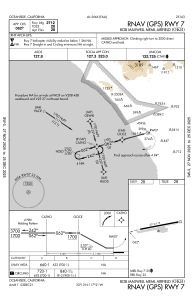
IAC chart of KOKB
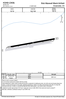
 ADC chart of KOKB
 Satellite view of KOKB
ADC chart of KOKB
Satellite view of KOKB
Sorry, we have no imagery here.
Sorry, we have no imagery here.
Sorry, we have no imagery here.
Sorry, we have no imagery here.
Sorry, we have no imagery here.
Sorry, we have no imagery here.


KOKB - Bob Maxwell Meml Airfield
Located in Oceanside, United States
ICAO - OKB, IATA -
Data provided by AirmateGeneral information
Coordinates: N33°13'5" W117°21'5"
Elevation is 28 feet MSL.
Magnetic variation is 13° East View others Airports in California
Operational data
Special qualification required
Current time UTC:
Current local time:
Weather
METAR: KOKB 051052Z AUTO 04003KT 6SM HZ CLR 07/M01 A3015 RMK AO2 SLP209 T00671011
Communications frequencies: [VIEW]
Runways:
| RWY identifier | QFU | Length (ft) | Width (ft) | Surface | LDA (ft) |
| 07 | 80° | 2712 | 75 | ASPH | |
| 25 | 260° | 2712 | 75 | ASPH |
Airport contact information
Address: Oceanside United States
Satellite view of KOKB
Sorry, we have no imagery here.
Sorry, we have no imagery here.
Sorry, we have no imagery here.
Sorry, we have no imagery here.
Sorry, we have no imagery here.
Sorry, we have no imagery here.