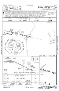
IAC chart of KOEO
 ADC chart of KOEO
 Satellite view of KOEO
ADC chart of KOEO
Satellite view of KOEO
Sorry, we have no imagery here.
Sorry, we have no imagery here.
Sorry, we have no imagery here.
Sorry, we have no imagery here.
Sorry, we have no imagery here.
Sorry, we have no imagery here.


KOEO - L O Simenstad Muni
Located in Osceola, United States
ICAO - OEO, IATA -
Data provided by AirmateGeneral information
Coordinates: N45°18'34" W92°41'24"
Elevation is 905 feet MSL.
Magnetic variation is 01° East View others Airports in Wisconsin
Operational data
Special qualification required
Current time UTC:
Current local time:
Weather
METAR: KOEO 280435Z AUTO 36003KT 10SM SCT065 OVC075 13/12 A3024 RMK AO2 T01300122 PWINO
Communications frequencies: [VIEW]
Runways:
| RWY identifier | QFU | Length (ft) | Width (ft) | Surface | LDA (ft) |
| 04 | 45° | 2192 | 150 | GRASS | |
| 22 | 225° | 2192 | 150 | GRASS | |
| 10 | 104° | 5006 | 75 | ASPH | |
| 28 | 284° | 5006 | 75 | ASPH |
Airport contact information
Address: Osceola United States
Other aviation service providers
Flight schools

Satellite view of KOEO
Sorry, we have no imagery here.
Sorry, we have no imagery here.
Sorry, we have no imagery here.
Sorry, we have no imagery here.
Sorry, we have no imagery here.
Sorry, we have no imagery here.