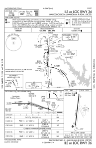
IAC chart of KOCH
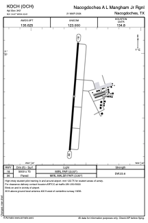
 ADC chart of KOCH
 Satellite view of KOCH
ADC chart of KOCH
Satellite view of KOCH
Sorry, we have no imagery here.
Sorry, we have no imagery here.
Sorry, we have no imagery here.
Sorry, we have no imagery here.
Sorry, we have no imagery here.
Sorry, we have no imagery here.


KOCH - Nacogdoches A L Mangham Jr Rgnl
Located in Nacogdoches, United States
ICAO - OCH, IATA -
Data provided by AirmateGeneral information
Coordinates: N31°34'40" W94°42'36"
Elevation is 343 feet MSL.
Magnetic variation is 05° East View others Airports in Texas
Operational data
Special qualification required
Current time UTC:
Current local time:
Weather
METAR: KOCH 020956Z AUTO 16011G17KT OVC022 23/21 A2963 RMK AO2 SLP035 T02330206 PWINO RVRNO $
Communications frequencies: [VIEW]
Runways:
| RWY identifier | QFU | Length (ft) | Width (ft) | Surface | LDA (ft) |
| 18 | 184° | 5000 | 75 | ASPH | |
| 36 | 4° | 5000 | 75 | ASPH |
Airport contact information
Address: Nacogdoches United States
Satellite view of KOCH
Sorry, we have no imagery here.
Sorry, we have no imagery here.
Sorry, we have no imagery here.
Sorry, we have no imagery here.
Sorry, we have no imagery here.
Sorry, we have no imagery here.