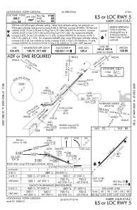
IAC chart of KOAJ
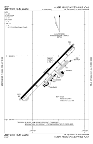
 ADC chart of KOAJ
 Satellite view of KOAJ
ADC chart of KOAJ
Satellite view of KOAJ
Sorry, we have no imagery here.
Sorry, we have no imagery here.
Sorry, we have no imagery here.
Sorry, we have no imagery here.
Sorry, we have no imagery here.
Sorry, we have no imagery here.


KOAJ - Albert J Ellis
Located in Jacksonville, United States
ICAO - OAJ, IATA - OAJ
Data provided by AirmateGeneral information
Coordinates: N34°49'45" W77°36'44"
Elevation is 92 feet MSL.
Magnetic variation is -08° East View others Airports in North Carolina
Operational data
Special qualification required
Current time UTC:
Current local time:
Weather
METAR: KOAJ 020756Z AUTO 04006KT 10SM CLR 09/09 A3023 RMK AO2 SLP239 T00940089
TAF: KOAJ 020527Z 0206/0306 07006KT P6SM FEW040 FM021200 08007KT P6SM SCT025 BKN040 FM021600 12011G17KT P6SM BKN025 FM030000 15008KT P6SM BKN020 AMD LTD TO CLD VIS AND WIND
Communications frequencies: [VIEW]
Runways:
| RWY identifier | QFU | Length (ft) | Width (ft) | Surface | LDA (ft) |
| 05 | 44° | 7100 | 150 | ASPH | |
| 23 | 224° | 7100 | 150 | ASPH |
Airport contact information
Address: Jacksonville United States
Satellite view of KOAJ
Sorry, we have no imagery here.
Sorry, we have no imagery here.
Sorry, we have no imagery here.
Sorry, we have no imagery here.
Sorry, we have no imagery here.
Sorry, we have no imagery here.