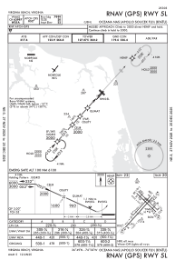
IAC chart of KNTU
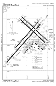
 ADC chart of KNTU
 Satellite view of KNTU
ADC chart of KNTU
Satellite view of KNTU
Sorry, we have no imagery here.
Sorry, we have no imagery here.
Sorry, we have no imagery here.
Sorry, we have no imagery here.
Sorry, we have no imagery here.
Sorry, we have no imagery here.


KNTU - Oceana Nas (Apollo Soucek Fld)
Located in Virginia Beach, United States
ICAO - NTU, IATA -
Data provided by AirmateGeneral information
Coordinates: N36°49'22" W76°1'55"
Elevation is 22 feet MSL.
Magnetic variation is -10° East View others Airports in Virginia
Operational data
Special qualification required
Current time UTC:
Current local time:
Weather
METAR: KNTU 011256Z 35015G23KT 10SM BKN046 13/06 A2993 RMK AO2 PK WND 34027/1217 SLP137 T01280061
TAF: TAF AMD KNTU 0111/0207 34018G28KT BKN030 BKN250 540009 QNH2984INS FM011500 35015G22KT FEW030 540009 QNH2990INS FM020100 05010KT 9999 FEW50 500000 QNH3015INS TX15/0118Z TN08/0207Z AMD 1150 FN20008
Communications frequencies: [VIEW]
Runways:
| RWY identifier | QFU | Length (ft) | Width (ft) | Surface | LDA (ft) |
| 05L | 42° | 8000 | 150 | OTHER | |
| 23R | 222° | 8000 | 150 | OTHER | |
| 05R | 42° | 12001 | 200 | OTHER | |
| 23L | 222° | 12001 | 200 | OTHER | |
| 14L | 134° | 8001 | 150 | OTHER | |
| 32R | 314° | 8001 | 150 | OTHER | |
| 14R | 134° | 8000 | 200 | OTHER | |
| 32L | 314° | 8000 | 200 | OTHER |
Airport contact information
Address: Virginia Beach United States
Satellite view of KNTU
Sorry, we have no imagery here.
Sorry, we have no imagery here.
Sorry, we have no imagery here.
Sorry, we have no imagery here.
Sorry, we have no imagery here.
Sorry, we have no imagery here.