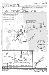
IAC chart of KNRB
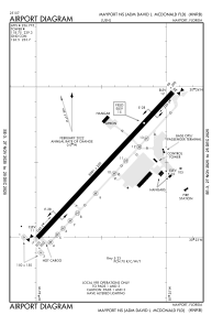
 ADC chart of KNRB
 Satellite view of KNRB
ADC chart of KNRB
Satellite view of KNRB
Sorry, we have no imagery here.
Sorry, we have no imagery here.
Sorry, we have no imagery here.
Sorry, we have no imagery here.
Sorry, we have no imagery here.
Sorry, we have no imagery here.


KNRB - Mayport Ns (Adm David L Mcdonald Fld)
Located in Mayport, United States
ICAO - NRB, IATA -
Data provided by AirmateGeneral information
Coordinates: N30°23'29" W81°25'28"
Elevation is 14 feet MSL.
Magnetic variation is -06° East View others Airports in Florida
Operational data
Special qualification required
Current time UTC:
Current local time:
Weather
METAR: KNRB 051352Z AUTO 20010KT 10SM FEW016 27/20 A3023 RMK AO2 SLP236 T02670200 $
Communications frequencies: [VIEW]
Runways:
| RWY identifier | QFU | Length (ft) | Width (ft) | Surface | LDA (ft) |
| 05 | 0° | 8001 | 200 | ASPH | |
| 23 | 0° | 8001 | 200 | ASPH |
Airport contact information
Address: Mayport United States
Satellite view of KNRB
Sorry, we have no imagery here.
Sorry, we have no imagery here.
Sorry, we have no imagery here.
Sorry, we have no imagery here.
Sorry, we have no imagery here.
Sorry, we have no imagery here.