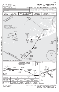
IAC chart of KNQX
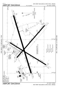
 ADC chart of KNQX
 Satellite view of KNQX
ADC chart of KNQX
Satellite view of KNQX
Sorry, we have no imagery here.
Sorry, we have no imagery here.
Sorry, we have no imagery here.
Sorry, we have no imagery here.
Sorry, we have no imagery here.
Sorry, we have no imagery here.


KNQX - Key West Nas (Boca Chica Fld)
Located in Key West, United States
ICAO - NQX, IATA -
Data provided by AirmateGeneral information
Coordinates: N24°34'29" W81°41'12"
Elevation is 5 feet MSL.
Magnetic variation is -06° East View others Airports in Florida
Operational data
Special qualification required
Current time UTC:
Current local time:
Weather
METAR: KNQX 050553Z AUTO 11020G29KT 10SM FEW022 27/22 A3013 RMK AO2 PK WND 12030/0507 SLP201 T02720222 10272 20261 58013 $
TAF: TAF KNQX 0423/0523 11020G30KT 9999 FEW025 SCT040 520005 QNH3008INS BECMG 0514/0516 12016G24KT 9999 FEW025 SCT250 520005 QNH2998INS AUTOMATED SENSOR METWATCH 0502 TIL 0510 TX31/0519Z TN25/0511Z FN20109
Communications frequencies: [VIEW]
Runways:
| RWY identifier | QFU | Length (ft) | Width (ft) | Surface | LDA (ft) |
| 04 | 32° | 7001 | 150 | OTHER | |
| 22 | 212° | 7001 | 150 | OTHER | |
| 08 | 73° | 10001 | 200 | OTHER | |
| 26 | 253° | 10001 | 200 | OTHER | |
| 14 | 131° | 7000 | 150 | OTHER | |
| 32 | 311° | 7000 | 150 | OTHER |
Airport contact information
Address: Key West United States
Satellite view of KNQX
Sorry, we have no imagery here.
Sorry, we have no imagery here.
Sorry, we have no imagery here.
Sorry, we have no imagery here.
Sorry, we have no imagery here.
Sorry, we have no imagery here.