IAC chart of KNOG
 ADC chart of KNOG
 Satellite view of KNOG
ADC chart of KNOG
Satellite view of KNOG
Sorry, we have no imagery here.
Sorry, we have no imagery here.
Sorry, we have no imagery here.
Sorry, we have no imagery here.
Sorry, we have no imagery here.
Sorry, we have no imagery here.


KNOG - Orange Grove Nalf
Located in Orange Grove, United States
ICAO - NOG, IATA -
Data provided by AirmateGeneral information
Coordinates: N27°53'49" W98°2'37"
Elevation is 257 feet MSL.
Magnetic variation is 05° East View others Airports in Texas
Operational data
Special qualification required
Current time UTC:
Current local time:
Weather
METAR: KNOG 012356Z AUTO 12021G27KT 10SM CLR 27/23 A2959 RMK AO2 PK WND 13032/2306 SLP999 6//// T02670228 10311 20267 55013 PNO $
Communications frequencies: [VIEW]
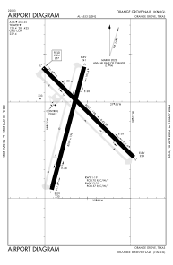
Runways:
| RWY identifier | QFU | Length (ft) | Width (ft) | Surface | LDA (ft) |
| 01 | 15° | 8000 | 198 | OTHER | |
| 19 | 195° | 8000 | 198 | OTHER | |
| 13 | 135° | 8001 | 198 | OTHER | |
| 31 | 315° | 8001 | 198 | OTHER |
Airport contact information
Address: Orange Grove United States
Satellite view of KNOG
Sorry, we have no imagery here.
Sorry, we have no imagery here.
Sorry, we have no imagery here.
Sorry, we have no imagery here.
Sorry, we have no imagery here.
Sorry, we have no imagery here.