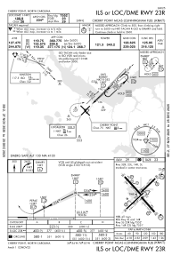
IAC chart of KNKT
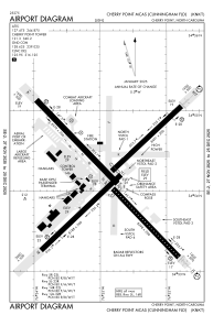
 ADC chart of KNKT
 Satellite view of KNKT
ADC chart of KNKT
Satellite view of KNKT
Sorry, we have no imagery here.
Sorry, we have no imagery here.
Sorry, we have no imagery here.
Sorry, we have no imagery here.
Sorry, we have no imagery here.
Sorry, we have no imagery here.


KNKT - Cherry Point Mcas (Cunningham Fld)
Located in Cherry Point, United States
ICAO - NKT, IATA -
Data provided by AirmateGeneral information
Coordinates: N34°54'11" W76°52'51"
Elevation is 29 feet MSL.
Magnetic variation is -09° East View others Airports in North Carolina
Operational data
Special qualification required
Current time UTC:
Current local time:
Weather
METAR: KNKT 020355Z 08004KT 10SM CLR 16/10 A3023 RMK AO2 SLP233 T01560100
TAF: TAF KNKT 0203/0303 VRB06KT 9999 SKC QNH3020INS BECMG 0207/0209 08010KT BKN020 QNH3024INS BECMG 0215/0217 12012G25KT 9999 OVC020 QNH3026INS TX23/0216Z TN12/0210Z
Communications frequencies: [VIEW]
Runways:
| RWY identifier | QFU | Length (ft) | Width (ft) | Surface | LDA (ft) |
| 05L | 45° | 8489 | 196 | ASPH | 7554 |
| 23R | 225° | 8489 | 196 | ASPH | 7554 |
| 05R | 45° | 8189 | 200 | ASPH | |
| 23L | 225° | 8189 | 200 | ASPH | |
| 14L | 136° | 8978 | 200 | ASPH | |
| 32R | 316° | 8978 | 200 | ASPH | |
| 14R | 136° | 8397 | 200 | ASPH | 7549 |
| 32L | 316° | 8397 | 200 | ASPH | 7549 |
Airport contact information
Address: Cherry Point United States
Satellite view of KNKT
Sorry, we have no imagery here.
Sorry, we have no imagery here.
Sorry, we have no imagery here.
Sorry, we have no imagery here.
Sorry, we have no imagery here.
Sorry, we have no imagery here.