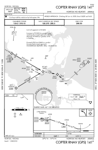
IAC chart of KNHU
 Satellite view of KNHU
Satellite view of KNHU
Sorry, we have no imagery here.
Sorry, we have no imagery here.
Sorry, we have no imagery here.
Sorry, we have no imagery here.
Sorry, we have no imagery here.
Sorry, we have no imagery here.


KNHU - Norfolk Ns
Located in Norfolk, United States
ICAO - NHU, IATA -
Data provided by AirmateGeneral information
Coordinates: N36°57'20" W76°18'14"
Elevation is 10 feet MSL.
Magnetic variation is -10° East View others Airports in Virginia
Operational data
Special qualification required
Current time UTC:
Current local time:
Weather at : KNGU - Norfolk Ns (Chambers Fld) ( 2 km )
METAR: KNGU 011159Z 35014G20KT 10SM BKN046 14/06 A2992 RMK AO2 PK WND 34026/1127 SLP132 70035 T01390061 10200 20139 51053
TAF: TAF AMD KNGU 0109/0207 01012KT 9999 FEW025 SCT050 QNH2978INS TEMPO 0109/0115 36013G22KT BKN020 OVC040 BECMG 0121/0123 03010KT 9999 FEW030 QNH3006INS BECMG 0200/0202 VRB06KT 9999 FEW200 QNH3017INS TX16/0118Z TN09/0110Z AMD 0925 FN20079
Communications frequencies: [VIEW]
Runways:
| RWY identifier | QFU | Length (ft) | Width (ft) | Surface | LDA (ft) |
| 09 | 86° | 1705 | 150 | ASPH | |
| 27 | 266° | 1705 | 150 | ASPH | |
| H1 | 0° | 0 | 0 | UNK | |
| H2 | 0° | 0 | 0 | UNK | |
| H3 | 0° | 0 | 0 | UNK | |
| H4 | 0° | 0 | 0 | UNK | |
| H5 | 0° | 0 | 0 | UNK | |
| H6 | 0° | 0 | 0 | UNK | |
| H7 | 0° | 0 | 0 | UNK | |
| H8 | 0° | 0 | 0 | UNK | |
| H9 | 0° | 0 | 0 | UNK |
Airport contact information
Address: Norfolk United States
Satellite view of KNHU
Sorry, we have no imagery here.
Sorry, we have no imagery here.
Sorry, we have no imagery here.
Sorry, we have no imagery here.
Sorry, we have no imagery here.
Sorry, we have no imagery here.