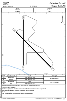
ADC chart of KNGW
 Satellite view of KNGW

Satellite view of KNGW
Sorry, we have no imagery here.
Sorry, we have no imagery here.
Sorry, we have no imagery here.
Sorry, we have no imagery here.
Sorry, we have no imagery here.
Sorry, we have no imagery here.


KNGW - Cabaniss Fld Nolf
Located in Corpus Christi, United States
ICAO - NGW, IATA -
Data provided by AirmateGeneral information
Coordinates: N27°42'9" W97°26'20"
Elevation is 31 feet MSL.
Magnetic variation is 05° East View others Airports in Texas
Operational data
Special qualification required
Current time UTC:
Current local time:
Weather at : KCRP - Corpus Christi Intl ( 10 km )
METAR: KCRP 021251Z 16019KT 8SM FEW009 BKN013 OVC250 24/22 A2953 RMK AO2 PK WND 17031/1156 SLP998 T02390222
TAF: KCRP 021137Z 0212/0312 16022G32KT P6SM FEW009 BKN015 FM021800 17015G22KT P6SM SCT030 FM022000 14020G28KT P6SM FEW020 SCT040 FM030400 15025G30KT 6SM BR BKN015
Communications frequencies: [VIEW]
Runways:
| RWY identifier | QFU | Length (ft) | Width (ft) | Surface | LDA (ft) |
| 13 | 135° | 4994 | 150 | ASPH | |
| 31 | 315° | 4994 | 150 | ASPH | |
| 18 | 180° | 4496 | 150 | OTHER | |
| 36 | 0° | 4496 | 150 | OTHER |
Airport contact information
Address: Corpus Christi United States
Satellite view of KNGW
Sorry, we have no imagery here.
Sorry, we have no imagery here.
Sorry, we have no imagery here.
Sorry, we have no imagery here.
Sorry, we have no imagery here.
Sorry, we have no imagery here.