ADC chart of KNFE
 Satellite view of KNFE
Satellite view of KNFE
Sorry, we have no imagery here.
Sorry, we have no imagery here.
Sorry, we have no imagery here.
Sorry, we have no imagery here.
Sorry, we have no imagery here.


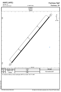
KNFE - Fentress Nalf
Located in Fentress, United States
ICAO - NFE, IATA -
Data provided by AirmateGeneral information
Coordinates: N36°41'31" W76°8'4"
Elevation is 16 feet MSL.
Magnetic variation is -09° East View others Airports in Virginia
Operational data
Special qualification required
Current time UTC:
Current local time:
Weather
METAR: KNFE 010658Z AUTO VRB05KT 10SM FEW012 19/17 A2967 RMK AO2 SLP050 T01890167
Communications frequencies: [VIEW]
Runways:
| RWY identifier | QFU | Length (ft) | Width (ft) | Surface | LDA (ft) |
| 05 | 40° | 8004 | 175 | ASPH | |
| 23 | 219° | 8004 | 175 | ASPH |
Airport contact information
Address: Fentress United States
Satellite view of KNFE
Sorry, we have no imagery here.
Sorry, we have no imagery here.
Sorry, we have no imagery here.
Sorry, we have no imagery here.
Sorry, we have no imagery here.