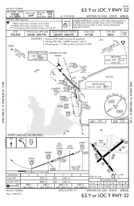
IAC chart of KNDZ
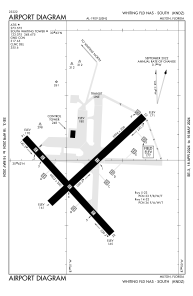
 ADC chart of KNDZ
 Satellite view of KNDZ
ADC chart of KNDZ
Satellite view of KNDZ
Sorry, we have no imagery here.
Sorry, we have no imagery here.
Sorry, we have no imagery here.
Sorry, we have no imagery here.
Sorry, we have no imagery here.
Sorry, we have no imagery here.


KNDZ - Whiting Fld Nas South
Located in Milton, United States
ICAO - NDZ, IATA -
Data provided by AirmateGeneral information
Coordinates: N30°41'55" W87°0'52"
Elevation is 177 feet MSL.
Magnetic variation is -02° East View others Airports in Florida
Operational data
Special qualification required
Current time UTC:
Current local time:
Weather
METAR: KNDZ 051056Z AUTO 16008KT 10SM OVC006 23/22 A3006 RMK AO2 SLP166 T02280217 $
Communications frequencies: [VIEW]
Runways:
| RWY identifier | QFU | Length (ft) | Width (ft) | Surface | LDA (ft) |
| 05 | 47° | 5996 | 200 | ASPH | |
| 23 | 227° | 5996 | 200 | ASPH | |
| 14 | 137° | 6002 | 200 | ASPH | |
| 32 | 317° | 6002 | 200 | ASPH |
Airport contact information
Address: Milton United States
Satellite view of KNDZ
Sorry, we have no imagery here.
Sorry, we have no imagery here.
Sorry, we have no imagery here.
Sorry, we have no imagery here.
Sorry, we have no imagery here.
Sorry, we have no imagery here.