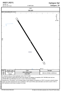
ADC chart of KNDY
 Satellite view of KNDY

Satellite view of KNDY
Sorry, we have no imagery here.
Sorry, we have no imagery here.
Sorry, we have no imagery here.
Sorry, we have no imagery here.
Sorry, we have no imagery here.
Sorry, we have no imagery here.


KNDY - Dahlgren Nsf
Located in Dahlgren, United States
ICAO - NDY, IATA - DGN
Data provided by AirmateGeneral information
Coordinates: N38°19'58" W77°2'13"
Elevation is 18 feet MSL.
Magnetic variation is -09° East View others Airports in Virginia
Operational data
Special qualification required
Current time UTC:
Current local time:
Weather at : KNYG - Quantico Mcaf (Turner Fld) ( 30 km )
METAR: KNYG 011556Z 32010G20KT 7SM CLR 12/01 A3009 RMK AO2 PK WND 29027/1530 SLP189 T01170006 $
TAF: TAF KNYG 0115/0215 34009KT 9999 SKC QNH3006INS BECMG 0200/0202 VRB06KT 9999 FEW120 QNH3017INS BECMG 0205/0207 10009KT 9999 SCT035 SCT080 QNH3028INS TX13/0120Z TN06/0209Z
Communications frequencies: [VIEW]
Runways:
| RWY identifier | QFU | Length (ft) | Width (ft) | Surface | LDA (ft) |
| 16 | 148° | 4191 | 150 | ASPH | |
| 34 | 328° | 4191 | 150 | ASPH |
Airport contact information
Address: Dahlgren United States
Satellite view of KNDY
Sorry, we have no imagery here.
Sorry, we have no imagery here.
Sorry, we have no imagery here.
Sorry, we have no imagery here.
Sorry, we have no imagery here.
Sorry, we have no imagery here.