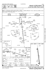
IAC chart of KMWK
 Satellite view of KMWK
Satellite view of KMWK
Sorry, we have no imagery here.
Sorry, we have no imagery here.
Sorry, we have no imagery here.
Sorry, we have no imagery here.
Sorry, we have no imagery here.
Sorry, we have no imagery here.


KMWK - Mount Airy/Surry County
Located in Mount Airy, United States
ICAO - MWK, IATA -
Data provided by AirmateGeneral information
Coordinates: N36°27'41" W80°33'12"
Elevation is 1268 feet MSL.
Magnetic variation is -07° East View others Airports in North Carolina
Operational data
Special qualification required
Current time UTC:
Current local time:
Weather
METAR: KMWK 021405Z AUTO 07005KT 10SM -RA OVC006 08/07 A3030 RMK AO2 T00820070
Communications frequencies: [VIEW]
Runways:
| RWY identifier | QFU | Length (ft) | Width (ft) | Surface | LDA (ft) |
| 18 | 173° | 5500 | 75 | ASPH | |
| 36 | 353° | 5500 | 75 | ASPH |
Airport contact information
Address: Mount Airy United States
Other aviation service providers
Flight schools

Satellite view of KMWK
Sorry, we have no imagery here.
Sorry, we have no imagery here.
Sorry, we have no imagery here.
Sorry, we have no imagery here.
Sorry, we have no imagery here.
Sorry, we have no imagery here.