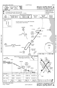
IAC chart of KMWC
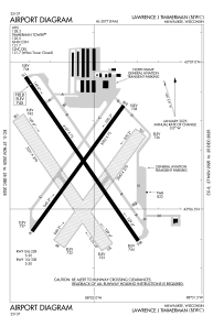
 ADC chart of KMWC
 Satellite view of KMWC
ADC chart of KMWC
Satellite view of KMWC
Sorry, we have no imagery here.
Sorry, we have no imagery here.
Sorry, we have no imagery here.
Sorry, we have no imagery here.
Sorry, we have no imagery here.
Sorry, we have no imagery here.


KMWC - Lawrence J Timmerman
Located in Milwaukee, United States
ICAO - MWC, IATA -
Data provided by AirmateGeneral information
Coordinates: N43°6'37" W88°2'4"
Elevation is 744 feet MSL.
Magnetic variation is -02° East View others Airports in Wisconsin
Operational data
Special qualification required
Current time UTC:
Current local time:
Weather
METAR: KMWC 232045Z 12006KT 10SM SCT060 13/05 A3010
Communications frequencies: [VIEW]
Runways:
| RWY identifier | QFU | Length (ft) | Width (ft) | Surface | LDA (ft) |
| 04L | 36° | 3203 | 75 | ASPH | |
| 22R | 216° | 3203 | 75 | ASPH | |
| 04R | 36° | 2840 | 270 | GRASS | |
| 22L | 216° | 2840 | 270 | GRASS | |
| 15L | 146° | 4107 | 75 | ASPH | |
| 33R | 326° | 4107 | 75 | ASPH | |
| 15R | 145° | 3231 | 270 | GRASS | |
| 33L | 325° | 3231 | 270 | GRASS |
Airport contact information
Address: Milwaukee United States
Other aviation service providers
Flight schools

Satellite view of KMWC
Sorry, we have no imagery here.
Sorry, we have no imagery here.
Sorry, we have no imagery here.
Sorry, we have no imagery here.
Sorry, we have no imagery here.
Sorry, we have no imagery here.