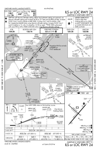
IAC chart of KMVY
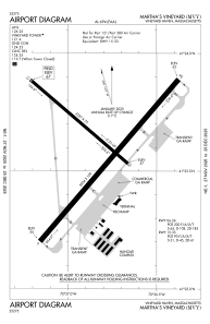
 ADC chart of KMVY
 Satellite view of KMVY
ADC chart of KMVY
Satellite view of KMVY
Sorry, we have no imagery here.
Sorry, we have no imagery here.
Sorry, we have no imagery here.
Sorry, we have no imagery here.
Sorry, we have no imagery here.
Sorry, we have no imagery here.


KMVY - Martha's Vineyard
Located in Vineyard Haven, United States
ICAO - MVY, IATA - MVY
Data provided by AirmateGeneral information
Coordinates: N41°23'36" W70°36'50"
Elevation is 66 feet MSL.
Magnetic variation is -15° East View others Airports in Massachusetts
Operational data
Special qualification required
Current time UTC:
Current local time:
Weather
METAR: KMVY 011553Z 33014KT 10SM CLR 11/04 A2979 RMK AO2 RAE02 SLP088 P0001 T01060044
Communications frequencies: [VIEW]
Runways:
| RWY identifier | QFU | Length (ft) | Width (ft) | Surface | LDA (ft) |
| 06 | 41° | 5504 | 100 | ASPH | 5504 |
| 24 | 221° | 5504 | 100 | ASPH | 5504 |
| 15 | 131° | 3327 | 75 | ASPH | 3327 |
| 33 | 311° | 3327 | 75 | ASPH | 3327 |
Airport contact information
Address: Vineyard Haven United States
Satellite view of KMVY
Sorry, we have no imagery here.
Sorry, we have no imagery here.
Sorry, we have no imagery here.
Sorry, we have no imagery here.
Sorry, we have no imagery here.
Sorry, we have no imagery here.