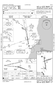
IAC chart of KMTW
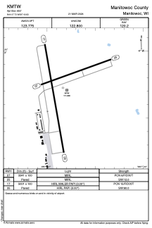
 ADC chart of KMTW
 Satellite view of KMTW
ADC chart of KMTW
Satellite view of KMTW
Sorry, we have no imagery here.
Sorry, we have no imagery here.
Sorry, we have no imagery here.
Sorry, we have no imagery here.
Sorry, we have no imagery here.
Sorry, we have no imagery here.


KMTW - Manitowoc County
Located in Manitowoc, United States
ICAO - MTW, IATA -
Data provided by AirmateGeneral information
Coordinates: N44°7'44" W87°40'50"
Elevation is 650 feet MSL.
Magnetic variation is -02° East View others Airports in Wisconsin
Operational data
Special qualification required
Current time UTC:
Current local time:
Weather
TAF: KMTW 301739Z 3018/3118 30009G16KT 6SM -SHRA FU FEW040 BKN090 FM302000 32010G17KT 6SM FU FEW040 BKN090 TEMPO 3022/3101 4SM -TSRA BKN030CB FM310300 35006KT 6SM FU SCT250 FM310900 36007KT P6SM SKC
Communications frequencies: [VIEW]
Runways:
| RWY identifier | QFU | Length (ft) | Width (ft) | Surface | LDA (ft) |
| 07 | 70° | 3341 | 100 | ASPH | |
| 25 | 250° | 3341 | 100 | ASPH | |
| 17 | 170° | 5001 | 100 | ASPH | |
| 35 | 350° | 5001 | 100 | ASPH |
Airport contact information
Address: Manitowoc United States
Other aviation service providers
Flight schools

Satellite view of KMTW
Sorry, we have no imagery here.
Sorry, we have no imagery here.
Sorry, we have no imagery here.
Sorry, we have no imagery here.
Sorry, we have no imagery here.
Sorry, we have no imagery here.