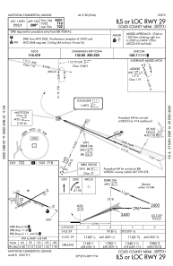
IAC chart of KMTO
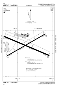
 ADC chart of KMTO
 Satellite view of KMTO
ADC chart of KMTO
Satellite view of KMTO
Sorry, we have no imagery here.
Sorry, we have no imagery here.
Sorry, we have no imagery here.
Sorry, we have no imagery here.
Sorry, we have no imagery here.
Sorry, we have no imagery here.


KMTO - Coles County Meml
Located in Mattoon/Charleston, United States
ICAO - MTO, IATA -
Data provided by AirmateGeneral information
Coordinates: N39°28'40" W88°16'48"
Elevation is 722 feet MSL.
Magnetic variation is -03° East View others Airports in Illinois
Operational data
Special qualification required
Current time UTC:
Current local time:
Weather
METAR: KMTO 080953Z AUTO 33004KT 10SM CLR M03/M05 A3013 RMK AO2 SLP209 T10331050
Communications frequencies: [VIEW]
Runways:
| RWY identifier | QFU | Length (ft) | Width (ft) | Surface | LDA (ft) |
| 06 | 60° | 5799 | 100 | ASPH | 5799 |
| 24 | 240° | 5799 | 100 | ASPH | 5799 |
| 11 | 113° | 6501 | 150 | ASPH | 6501 |
| 29 | 293° | 6501 | 150 | ASPH | 6501 |
| 18 | 175° | 1098 | 250 | GRASS | 1080 |
| 36 | 355° | 1098 | 250 | GRASS | 1080 |
Airport contact information
Address: Mattoon/Charleston United States
Satellite view of KMTO
Sorry, we have no imagery here.
Sorry, we have no imagery here.
Sorry, we have no imagery here.
Sorry, we have no imagery here.
Sorry, we have no imagery here.
Sorry, we have no imagery here.