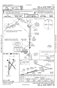
IAC chart of KMSN
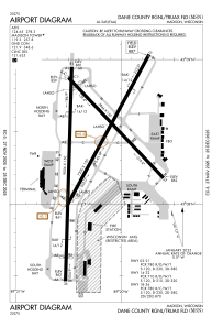
 ADC chart of KMSN
 Satellite view of KMSN
ADC chart of KMSN
Satellite view of KMSN
Sorry, we have no imagery here.
Sorry, we have no imagery here.
Sorry, we have no imagery here.
Sorry, we have no imagery here.
Sorry, we have no imagery here.
Sorry, we have no imagery here.


KMSN - Dane County Rgnl/Truax Fld
Located in Madison, United States
ICAO - MSN, IATA - MSN
Data provided by AirmateGeneral information
Coordinates: N43°8'24" W89°20'15"
Elevation is 886 feet MSL.
Magnetic variation is -03° East View others Airports in Wisconsin
Operational data
Special qualification required
Current time UTC:
Current local time:
Weather
METAR: KMSN 282253Z 35008KT 10SM FEW017 OVC060 14/11 A3008 RMK AO2 SLP188 T01440111
TAF: KMSN 282057Z 2821/2918 34006KT P6SM SCT035 OVC050 FM291600 32005KT P6SM BKN050
Communications frequencies: [VIEW]
Runways:
| RWY identifier | QFU | Length (ft) | Width (ft) | Surface | LDA (ft) |
| 03 | 29° | 7200 | 150 | CONC | 6770 |
| 21 | 209° | 7200 | 150 | CONC | 7015 |
| 14 | 136° | 5846 | 150 | CONC | 5369 |
| 32 | 316° | 5846 | 150 | CONC | 5846 |
| 18 | 182° | 9006 | 150 | CONC | 8606 |
| 36 | 2° | 9006 | 150 | CONC | 8006 |
Airport contact information
Address: Madison United States

Satellite view of KMSN
Sorry, we have no imagery here.
Sorry, we have no imagery here.
Sorry, we have no imagery here.
Sorry, we have no imagery here.
Sorry, we have no imagery here.
Sorry, we have no imagery here.