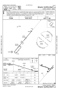
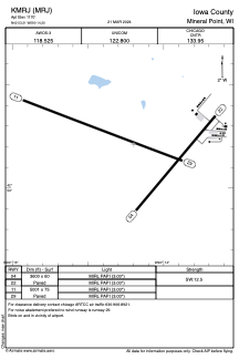
IAC chart of KMRJ
ADC chart of KMRJ
Satellite view of KMRJ
Sorry, we have no imagery here.
To navigate, press the arrow keys.
KMRJ - Iowa County
Located in Mineral Point, United States
ICAO - MRJ, IATA -
Data provided by
Airmate
General information
Coordinates:
N42°53'13" W90°14'12"
Elevation is
1170 feet MSL.
Magnetic variation is
-00° East
Add your vote
Valid your vote
View others
Airports in
Wisconsin
Operational data
Special qualification required
Current time UTC:
Current local time:
Weather
METAR:
KMRJ 120515Z AUTO 12006KT 10SM CLR 14/04 A3017 RMK AO2 PWINO
View NOTAMs / SUP AIP / TFR affecting this airport
[VIEW]
Communications frequencies:
[VIEW]
Runways:
RWY identifier
QFU
Length
(ft)
Width
(ft)
Surface
LDA
(ft)
04
40°
3600
60
ASPH
22
220°
3600
60
ASPH
11
111°
5001
75
ASPH
29
291°
5001
75
ASPH
Airport contact information
Address:
Mineral Point United States
Other aviation service providers
Flight schools
WEB
Point Aviation, Llc
Point Aviation, Llc
info@pointaviation.com
+1(608)987-3591
Add your vote
Valid your vote
Satellite view of KMRJ
Sorry, we have no imagery here.
To navigate, press the arrow keys.
<<
BESbswy
BESbswy