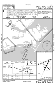
IAC chart of KMRH
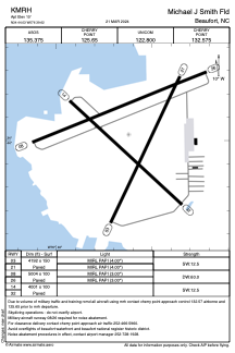
 ADC chart of KMRH
 Satellite view of KMRH
ADC chart of KMRH
Satellite view of KMRH
Sorry, we have no imagery here.
Sorry, we have no imagery here.
Sorry, we have no imagery here.
Sorry, we have no imagery here.
Sorry, we have no imagery here.
Sorry, we have no imagery here.


KMRH - Michael J Smith Fld
Located in Beaufort, United States
ICAO - MRH, IATA -
Data provided by AirmateGeneral information
Coordinates: N34°44'2" W76°39'37"
Elevation is 10 feet MSL.
Magnetic variation is -08° East View others Airports in North Carolina
Operational data
Special qualification required
Current time UTC:
Current local time:
Weather
METAR: KMRH 012258Z AUTO 07010G19KT 10SM CLR 17/11 A3009 RMK AO2 SLP191 T01670111
Communications frequencies: [VIEW]
Runways:
| RWY identifier | QFU | Length (ft) | Width (ft) | Surface | LDA (ft) |
| 03 | 25° | 4192 | 150 | ASPH | |
| 21 | 205° | 4192 | 150 | ASPH | |
| 08 | 68° | 5004 | 100 | ASPH | |
| 26 | 248° | 5004 | 100 | ASPH | |
| 14 | 133° | 4001 | 100 | ASPH | |
| 32 | 313° | 4001 | 100 | ASPH |
Airport contact information
Address: Beaufort United States
Other aviation service providers
Flight schools

Satellite view of KMRH
Sorry, we have no imagery here.
Sorry, we have no imagery here.
Sorry, we have no imagery here.
Sorry, we have no imagery here.
Sorry, we have no imagery here.
Sorry, we have no imagery here.