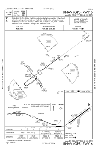
IAC chart of KMRC
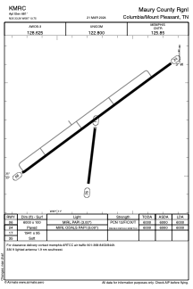
 ADC chart of KMRC
 Satellite view of KMRC
ADC chart of KMRC
Satellite view of KMRC
Sorry, we have no imagery here.
Sorry, we have no imagery here.
Sorry, we have no imagery here.
Sorry, we have no imagery here.
Sorry, we have no imagery here.
Sorry, we have no imagery here.


KMRC - Maury County Rgnl
Located in Columbia/Mount Pleasant, United States
ICAO - MRC, IATA - MRC
Data provided by AirmateGeneral information
Coordinates: N35°33'16" W87°10'45"
Elevation is 681 feet MSL.
Magnetic variation is -01° East View others Airports in Tennessee
Operational data
Special qualification required
Current time UTC:
Current local time:
Weather
METAR: KMRC 080955Z AUTO VRB04KT 10SM SCT044 05/05 A2999 RMK A01
Communications frequencies: [VIEW]
Runways:
| RWY identifier | QFU | Length (ft) | Width (ft) | Surface | LDA (ft) |
| 06 | 54° | 6000 | 100 | ASPH | 6000 |
| 24 | 234° | 6000 | 100 | ASPH | 6000 |
| 17 | 187° | 1941 | 95 | GRASS | |
| 35 | 7° | 1941 | 95 | GRASS | |
| H1 | 0° | 0 | 0 | UNK |
Airport contact information
Address: Columbia/Mount Pleasant United States
Satellite view of KMRC
Sorry, we have no imagery here.
Sorry, we have no imagery here.
Sorry, we have no imagery here.
Sorry, we have no imagery here.
Sorry, we have no imagery here.
Sorry, we have no imagery here.