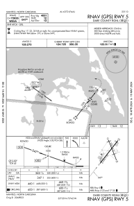
IAC chart of KMQI
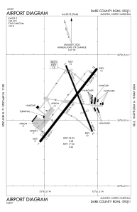
 ADC chart of KMQI
 Satellite view of KMQI
ADC chart of KMQI
Satellite view of KMQI
Sorry, we have no imagery here.
Sorry, we have no imagery here.
Sorry, we have no imagery here.
Sorry, we have no imagery here.
Sorry, we have no imagery here.


KMQI - Dare County Rgnl
Located in Manteo, United States
ICAO - MQI, IATA - MEO
Data provided by AirmateGeneral information
Coordinates: N35°55'8" W75°41'44"
Elevation is 13 feet MSL.
Magnetic variation is -09° East View others Airports in North Carolina
Operational data
Special qualification required
Current time UTC:
Current local time:
Weather
METAR: KMQI 021310Z AUTO 08011KT 10SM CLR 13/07 A3038 RMK AO2 T01300071
Communications frequencies: [VIEW]
Runways:
| RWY identifier | QFU | Length (ft) | Width (ft) | Surface | LDA (ft) |
| 05 | 38° | 4306 | 100 | ASPH | |
| 23 | 218° | 4306 | 100 | ASPH | |
| 17 | 158° | 3303 | 75 | ASPH | |
| 35 | 338° | 3303 | 75 | ASPH |
Airport contact information
Address: Manteo United States
Other aviation service providers
Flight schools

Barrier Island Aviation, Ltd
Barrier Island Aviation, Ltd
mail@barrierislandaviation.com+1(252)473-4247
Satellite view of KMQI
Sorry, we have no imagery here.
Sorry, we have no imagery here.
Sorry, we have no imagery here.
Sorry, we have no imagery here.
Sorry, we have no imagery here.