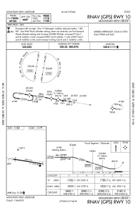
IAC chart of KMNF
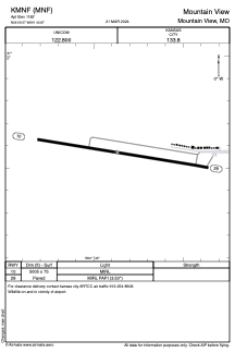
 ADC chart of KMNF
 Satellite view of KMNF
ADC chart of KMNF
Satellite view of KMNF
Sorry, we have no imagery here.
Sorry, we have no imagery here.
Sorry, we have no imagery here.
Sorry, we have no imagery here.
Sorry, we have no imagery here.
Sorry, we have no imagery here.


KMNF - Mountain View
Located in Mountain View, United States
ICAO - MNF, IATA -
Data provided by AirmateGeneral information
Coordinates: N36°59'34" W91°42'52"
Elevation is 1182 feet MSL.
Magnetic variation is -00° East View others Airports in Missouri
Operational data
Special qualification required
Current time UTC:
Current local time:
Weather at : KUNO - West Plains Rgnl ( 21 km )
METAR: KUNO 051053Z AUTO 01012G19KT 6SM -RA BR BKN011 OVC024 08/06 A2998 RMK AO2 RAB51 SLP151 P0000 T00830061
Communications frequencies: [VIEW]
Runways:
| RWY identifier | QFU | Length (ft) | Width (ft) | Surface | LDA (ft) |
| 10 | 99° | 5005 | 75 | ASPH | |
| 28 | 279° | 5005 | 75 | ASPH |
Airport contact information
Address: Mountain View United States
Satellite view of KMNF
Sorry, we have no imagery here.
Sorry, we have no imagery here.
Sorry, we have no imagery here.
Sorry, we have no imagery here.
Sorry, we have no imagery here.
Sorry, we have no imagery here.