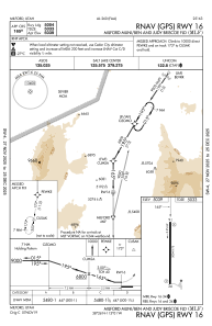
IAC chart of KMLF
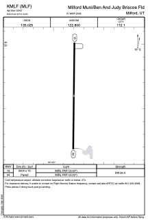
 ADC chart of KMLF
 Satellite view of KMLF
ADC chart of KMLF
Satellite view of KMLF
Sorry, we have no imagery here.
Sorry, we have no imagery here.
Sorry, we have no imagery here.
Sorry, we have no imagery here.
Sorry, we have no imagery here.
Sorry, we have no imagery here.


KMLF - Milford Muni/Ben And Judy Briscoe Fld
Located in Milford, United States
ICAO - MLF, IATA -
Data provided by AirmateGeneral information
Coordinates: N38°25'36" W113°0'48"
Elevation is 5042 feet MSL.
Magnetic variation is 15° East View others Airports in Utah
Operational data
Special qualification required
Current time UTC:
Current local time:
Weather
METAR: KMLF 010725Z AUTO 01020G28KT 10SM -RA BKN020 BKN050 OVC080 02/01 A2969 RMK AO2 PK WND 02028/0722 P0000 T00220006
Communications frequencies: [VIEW]
Runways:
| RWY identifier | QFU | Length (ft) | Width (ft) | Surface | LDA (ft) |
| 16 | 180° | 5004 | 75 | ASPH | |
| 34 | 0° | 5004 | 75 | ASPH |
Airport contact information
Address: Milford United States
Satellite view of KMLF
Sorry, we have no imagery here.
Sorry, we have no imagery here.
Sorry, we have no imagery here.
Sorry, we have no imagery here.
Sorry, we have no imagery here.
Sorry, we have no imagery here.