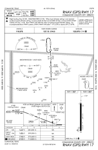
IAC chart of KMKN
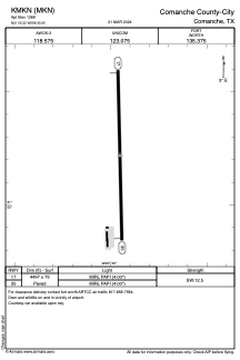
 ADC chart of KMKN
 Satellite view of KMKN
ADC chart of KMKN
Satellite view of KMKN
Sorry, we have no imagery here.
Sorry, we have no imagery here.
Sorry, we have no imagery here.
Sorry, we have no imagery here.
Sorry, we have no imagery here.
Sorry, we have no imagery here.


KMKN - Comanche County-City
Located in Comanche, United States
ICAO - MKN, IATA -
Data provided by AirmateGeneral information
Coordinates: N31°55'13" W98°35'57"
Elevation is 1386 feet MSL.
Magnetic variation is 06° East View others Airports in Texas
Operational data
Special qualification required
Current time UTC:
Current local time:
Weather
METAR: KMKN 021315Z AUTO 19012G18KT 7SM SCT025 SCT041 BKN055 23/20 A2956 RMK AO2 T02320198
Communications frequencies: [VIEW]
Runways:
| RWY identifier | QFU | Length (ft) | Width (ft) | Surface | LDA (ft) |
| 17 | 179° | 4497 | 75 | ASPH | |
| 35 | 359° | 4497 | 75 | ASPH |
Airport contact information
Address: Comanche United States
Satellite view of KMKN
Sorry, we have no imagery here.
Sorry, we have no imagery here.
Sorry, we have no imagery here.
Sorry, we have no imagery here.
Sorry, we have no imagery here.
Sorry, we have no imagery here.