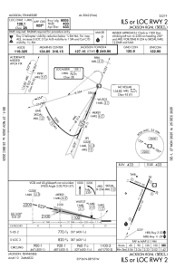
IAC chart of KMKL
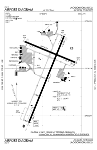
 ADC chart of KMKL
 Satellite view of KMKL
ADC chart of KMKL
Satellite view of KMKL
Sorry, we have no imagery here.
Sorry, we have no imagery here.
Sorry, we have no imagery here.
Sorry, we have no imagery here.
Sorry, we have no imagery here.
Sorry, we have no imagery here.


KMKL - Jackson Rgnl
Located in Jackson, United States
ICAO - MKL, IATA - MKL
Data provided by AirmateGeneral information
Coordinates: N35°35'60" W88°54'56"
Elevation is 433 feet MSL.
Magnetic variation is -01° East View others Airports in Tennessee
Operational data
Special qualification required
Current time UTC:
Current local time:
Weather
METAR: KMKL 081453Z 02010KT 10SM CLR 09/M01 A3018 RMK AO1 SLP222 6//// T00891011 51026 PNO $
TAF: KMKL 081120Z 0812/0912 02008KT P6SM SKC FM082100 10008KT P6SM SKC FM090200 11004KT P6SM SKC
Communications frequencies: [VIEW]
Runways:
| RWY identifier | QFU | Length (ft) | Width (ft) | Surface | LDA (ft) |
| 02 | 22° | 6005 | 150 | ASPH | |
| 20 | 202° | 6005 | 150 | ASPH | |
| 11 | 112° | 3539 | 100 | ASPH | |
| 29 | 292° | 3539 | 100 | ASPH |
Airport contact information
Address: Jackson United States
Satellite view of KMKL
Sorry, we have no imagery here.
Sorry, we have no imagery here.
Sorry, we have no imagery here.
Sorry, we have no imagery here.
Sorry, we have no imagery here.
Sorry, we have no imagery here.