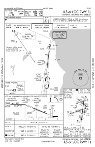
IAC chart of KMKE
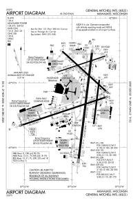
 ADC chart of KMKE
 Satellite view of KMKE
ADC chart of KMKE
Satellite view of KMKE
Sorry, we have no imagery here.
Sorry, we have no imagery here.
Sorry, we have no imagery here.
Sorry, we have no imagery here.
Sorry, we have no imagery here.
Sorry, we have no imagery here.


KMKE - General Mitchell Intl
Located in Milwaukee, United States
ICAO - MKE, IATA - MKE
Data provided by AirmateGeneral information
Coordinates: N42°56'49" W87°53'49"
Elevation is 728 feet MSL.
Magnetic variation is -04° East View others Airports in Wisconsin
Operational data
Special qualification required
Current time UTC:
Current local time:
Weather
METAR: KMKE 301852Z 30009KT 10SM BKN120 OVC250 21/11 A2974 RMK AO2 SLP070 T02110111
TAF: KMKE 301720Z 3018/3124 28011KT P6SM BKN120 FM302000 29011G19KT 6SM FU BKN110 PROB30 3022/3102 4SM TSRA BKN100CB FM310200 35008KT 6SM FU BKN090 PROB30 3102/3104 4SM -TSRA BKN100CB FM310800 36006KT P6SM SCT220 FM312300 VRB04KT P6SM FEW250
Communications frequencies: [VIEW]
Runways:
| RWY identifier | QFU | Length (ft) | Width (ft) | Surface | LDA (ft) |
| 01L | 7° | 9990 | 200 | OTHER | 9080 |
| 19R | 187° | 9990 | 200 | OTHER | 9205 |
| 01R | 7° | 4182 | 150 | OTHER | 4182 |
| 19L | 187° | 4182 | 150 | OTHER | 4182 |
| 07L | 72° | 4797 | 100 | OTHER | 4797 |
| 25R | 252° | 4797 | 100 | OTHER | 4797 |
| 07R | 72° | 8300 | 150 | OTHER | 8012 |
| 25L | 252° | 8300 | 150 | OTHER | 7867 |
| 13 | 132° | 5537 | 150 | OTHER | 4797 |
| 31 | 312° | 5537 | 150 | OTHER | 5152 |
Airport contact information
Address: Milwaukee United States
Other aviation service providers
Flight schools

Satellite view of KMKE
Sorry, we have no imagery here.
Sorry, we have no imagery here.
Sorry, we have no imagery here.
Sorry, we have no imagery here.
Sorry, we have no imagery here.
Sorry, we have no imagery here.