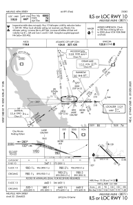
IAC chart of KMIV
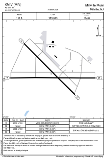
 ADC chart of KMIV
 Satellite view of KMIV
ADC chart of KMIV
Satellite view of KMIV
Sorry, we have no imagery here.
Sorry, we have no imagery here.
Sorry, we have no imagery here.
Sorry, we have no imagery here.
Sorry, we have no imagery here.
Sorry, we have no imagery here.


KMIV - Millville Muni
Located in Millville, United States
ICAO - MIV, IATA -
Data provided by AirmateGeneral information
Coordinates: N39°22'4" W75°4'20"
Elevation is 84 feet MSL.
Magnetic variation is -11° East View others Airports in New Jersey
Operational data
Special qualification required
Current time UTC:
Current local time:
Weather
METAR: KMIV 051305Z AUTO 11009G17KT 10SM OVC029 14/03 A3023 RMK AO2 T01440028
TAF: KMIV 051304Z 0513/0612 11011KT P6SM VCSH OVC040 TEMPO 0515/0517 6SM -SHRA OVC010 FM051700 12010KT P6SM OVC009 WS020/20040KT FM052000 12007KT 4SM BR OVC004 WS020/21045KT FM060500 19006KT 3SM BR SCT004 OVC050
Communications frequencies: [VIEW]
Runways:
| RWY identifier | QFU | Length (ft) | Width (ft) | Surface | LDA (ft) |
| 10 | 90° | 6003 | 150 | ASPH | |
| 28 | 270° | 6003 | 150 | ASPH | |
| 14 | 135° | 5058 | 150 | CONC | |
| 32 | 315° | 5058 | 150 | CONC |
Airport contact information
Address: Millville United States
Other aviation service providers
Flight schools

Satellite view of KMIV
Sorry, we have no imagery here.
Sorry, we have no imagery here.
Sorry, we have no imagery here.
Sorry, we have no imagery here.
Sorry, we have no imagery here.
Sorry, we have no imagery here.