IAC chart of KMIE
 ADC chart of KMIE
 Satellite view of KMIE
ADC chart of KMIE
Satellite view of KMIE
Sorry, we have no imagery here.
Sorry, we have no imagery here.
Sorry, we have no imagery here.
Sorry, we have no imagery here.
Sorry, we have no imagery here.
Sorry, we have no imagery here.


KMIE - Delaware County Rgnl
Located in Muncie, United States
ICAO - MIE, IATA - MIE
Data provided by AirmateGeneral information
Coordinates: N40°14'33" W85°23'45"
Elevation is 937 feet MSL.
Magnetic variation is -03° East View others Airports in Indiana
Operational data
Special qualification required
Current time UTC:
Current local time:
Weather
METAR: KMIE 051253Z 22009G18KT 10SM OVC013 17/14 A2992 RMK AO2 SLP126 T01670144
Communications frequencies: [VIEW]
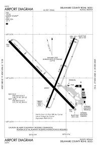
Runways:
| RWY identifier | QFU | Length (ft) | Width (ft) | Surface | LDA (ft) |
| 03 | 22° | 5198 | 100 | ASPH | 5197 |
| 21 | 202° | 5198 | 100 | ASPH | 5197 |
| 14 | 136° | 6500 | 150 | ASPH | 6500 |
| 32 | 316° | 6500 | 150 | ASPH | 6500 |
Airport contact information
Address: Muncie United States
Other aviation service providers
Repair station

Satellite view of KMIE
Sorry, we have no imagery here.
Sorry, we have no imagery here.
Sorry, we have no imagery here.
Sorry, we have no imagery here.
Sorry, we have no imagery here.
Sorry, we have no imagery here.