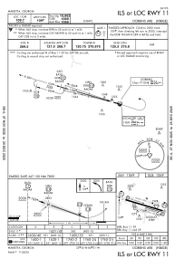
IAC chart of KMGE
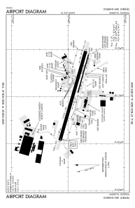
 ADC chart of KMGE
 Satellite view of KMGE
ADC chart of KMGE
Satellite view of KMGE
Sorry, we have no imagery here.
Sorry, we have no imagery here.
Sorry, we have no imagery here.
Sorry, we have no imagery here.
Sorry, we have no imagery here.
Sorry, we have no imagery here.


KMGE - Dobbins Arb
Located in Marietta, United States
ICAO - MGE, IATA - MGE
Data provided by AirmateGeneral information
Coordinates: N33°54'52" W84°30'51"
Elevation is 1068 feet MSL.
Magnetic variation is -03° East View others Airports in Georgia
Operational data
Special qualification required
Current time UTC:
Current local time:
Weather
METAR: KMGE 051355Z 17005KT 10SM SCT014 SCT250 23/19 A3016 RMK AO2A SLP203 T02330186 $
TAF: TAF KMGE 051305Z 0513/0619 15008KT 9999 FEW010 SCT250 QNH3016INS BECMG 0513/0514 17010G15KT 9999 SCT010 BKN250 QNH3014INS BECMG 0515/0516 18010G20KT 9999 BKN020 BKN250 QNH3014INS BECMG 0517/0518 19012G20KT 9999 SCT050 SCT250 QNH3010INS BECMG 0519/0520 19015G25KT 9999 BKN050 BKN250 QNH3002INS BECMG 0600/0601 19010KT 9999 FEW060 SCT250 QNH3000INS BECMG 0609/0610 20010KT 9999 VCSH SCT010 OVC020 QNH3000INS BECMG 0617/0618 20010G15KT 9000 -SHRA BKN012 OVC020 QNH2990INS TX30/0520Z TN20/0612Z LAST NO AMDS AFT 0520 NEXT 0611
Communications frequencies: [VIEW]
Runways:
| RWY identifier | QFU | Length (ft) | Width (ft) | Surface | LDA (ft) |
| 11 | 106° | 10002 | 300 | CONC | |
| 29 | 286° | 10002 | 300 | CONC | |
| 110 | 106° | 3495 | 60 | CONC | |
| 290 | 286° | 3495 | 60 | CONC |
Airport contact information
Address: Marietta United States
Satellite view of KMGE
Sorry, we have no imagery here.
Sorry, we have no imagery here.
Sorry, we have no imagery here.
Sorry, we have no imagery here.
Sorry, we have no imagery here.
Sorry, we have no imagery here.