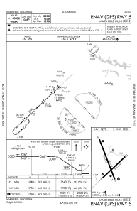
IAC chart of KMFI
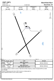
 ADC chart of KMFI
 Satellite view of KMFI
ADC chart of KMFI
Satellite view of KMFI
Sorry, we have no imagery here.
Sorry, we have no imagery here.
Sorry, we have no imagery here.
Sorry, we have no imagery here.
Sorry, we have no imagery here.
Sorry, we have no imagery here.


KMFI - Marshfield Muni
Located in Marshfield, United States
ICAO - MFI, IATA - MFI
Data provided by AirmateGeneral information
Coordinates: N44°38'13" W90°11'22"
Elevation is 1277 feet MSL.
Magnetic variation is 00° East View others Airports in Wisconsin
Operational data
Special qualification required
Current time UTC:
Current local time:
Weather
METAR: KMFI 301954Z AUTO 30015G21KT 10SM CLR 23/11 A2979 RMK AO2 PK WND 31026/1924 SLP084 T02330106
Communications frequencies: [VIEW]
Runways:
| RWY identifier | QFU | Length (ft) | Width (ft) | Surface | LDA (ft) |
| 05 | 46° | 3597 | 100 | ASPH | |
| 23 | 227° | 3597 | 100 | ASPH | |
| 16 | 159° | 5002 | 100 | ASPH | |
| 34 | 339° | 5002 | 100 | ASPH |
Airport contact information
Address: Marshfield United States
Other aviation service providers
Flight schools

Duffys Aircraft Sales & Leasing, Inc.
Duffys Aircraft Sales & Leasing, Inc.
jeff@duffysaircraft.com7153872211
Satellite view of KMFI
Sorry, we have no imagery here.
Sorry, we have no imagery here.
Sorry, we have no imagery here.
Sorry, we have no imagery here.
Sorry, we have no imagery here.
Sorry, we have no imagery here.