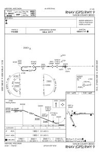
IAC chart of KMDZ
 ADC chart of KMDZ
 Satellite view of KMDZ
ADC chart of KMDZ
Satellite view of KMDZ
Sorry, we have no imagery here.
Sorry, we have no imagery here.
Sorry, we have no imagery here.
Sorry, we have no imagery here.
Sorry, we have no imagery here.
Sorry, we have no imagery here.


KMDZ - Taylor County
Located in Medford, United States
ICAO - MDZ, IATA - MDF
Data provided by AirmateGeneral information
Coordinates: N45°6'5" W90°18'1"
Elevation is 1478 feet MSL.
Magnetic variation is 00° East View others Airports in Wisconsin
Operational data
Special qualification required
Current time UTC:
Current local time:
Weather
METAR: KMDZ 241435Z AUTO 10004KT 10SM CLR 11/02 A3023 RMK AO2 T01120019 PWINO
Communications frequencies: [VIEW]
Runways:
| RWY identifier | QFU | Length (ft) | Width (ft) | Surface | LDA (ft) |
| 09 | 89° | 6000 | 100 | ASPH | |
| 27 | 269° | 6000 | 100 | ASPH | |
| 16 | 156° | 4435 | 75 | ASPH | |
| 34 | 336° | 4435 | 75 | ASPH |
Airport contact information
Address: Medford United States
Satellite view of KMDZ
Sorry, we have no imagery here.
Sorry, we have no imagery here.
Sorry, we have no imagery here.
Sorry, we have no imagery here.
Sorry, we have no imagery here.
Sorry, we have no imagery here.