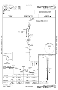
IAC chart of KMCX
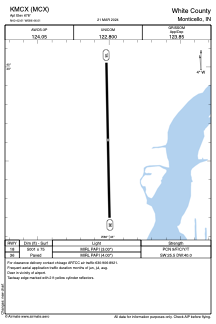
 ADC chart of KMCX
 Satellite view of KMCX
ADC chart of KMCX
Satellite view of KMCX
Sorry, we have no imagery here.
Sorry, we have no imagery here.
Sorry, we have no imagery here.
Sorry, we have no imagery here.
Sorry, we have no imagery here.
Sorry, we have no imagery here.


KMCX - White County
Located in Monticello, United States
ICAO - MCX, IATA -
Data provided by AirmateGeneral information
Coordinates: N40°42'37" W86°46'0"
Elevation is 678 feet MSL.
Magnetic variation is -03° East View others Airports in Indiana
Operational data
Special qualification required
Current time UTC:
Current local time:
Weather
METAR: KMCX 051055Z AUTO 34010KT 4SM DZ OVC005 07/06 A2995 RMK AO2 P0002 T00650058
Communications frequencies: [VIEW]
Runways:
| RWY identifier | QFU | Length (ft) | Width (ft) | Surface | LDA (ft) |
| 18 | 179° | 5001 | 75 | ASPH | |
| 36 | 359° | 5001 | 75 | ASPH |
Airport contact information
Address: Monticello United States
Satellite view of KMCX
Sorry, we have no imagery here.
Sorry, we have no imagery here.
Sorry, we have no imagery here.
Sorry, we have no imagery here.
Sorry, we have no imagery here.
Sorry, we have no imagery here.