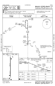
IAC chart of KLYO
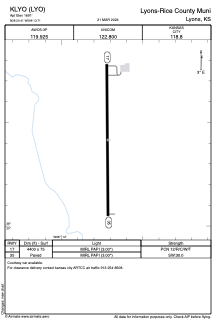
 ADC chart of KLYO
 Satellite view of KLYO
ADC chart of KLYO
Satellite view of KLYO
Sorry, we have no imagery here.
Sorry, we have no imagery here.
Sorry, we have no imagery here.
Sorry, we have no imagery here.
Sorry, we have no imagery here.
Sorry, we have no imagery here.


KLYO - Lyons-Rice County Muni
Located in Lyons, United States
ICAO - LYO, IATA - LYO
Data provided by AirmateGeneral information
Coordinates: N38°20'25" W98°13'43"
Elevation is 1691 feet MSL.
Magnetic variation is 06° East View others Airports in Kansas
Operational data
Special qualification required
Current time UTC:
Current local time:
Weather
METAR: KLYO 120415Z AUTO 15009KT 10SM CLR 11/01 A3011 RMK AO2 T01070014
Communications frequencies: [VIEW]
Runways:
| RWY identifier | QFU | Length (ft) | Width (ft) | Surface | LDA (ft) |
| 17 | 180° | 4400 | 75 | CONC | |
| 35 | 360° | 4400 | 75 | CONC |
Airport contact information
Address: Lyons United States
Satellite view of KLYO
Sorry, we have no imagery here.
Sorry, we have no imagery here.
Sorry, we have no imagery here.
Sorry, we have no imagery here.
Sorry, we have no imagery here.
Sorry, we have no imagery here.