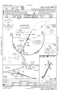
IAC chart of KLYH
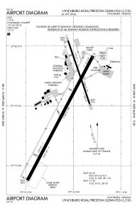
 ADC chart of KLYH
 Satellite view of KLYH
ADC chart of KLYH
Satellite view of KLYH
Sorry, we have no imagery here.
Sorry, we have no imagery here.
Sorry, we have no imagery here.
Sorry, we have no imagery here.
Sorry, we have no imagery here.
Sorry, we have no imagery here.


KLYH - Lynchburg Rgnl/Preston Glenn Fld
Located in Lynchburg, United States
ICAO - LYH, IATA - LYH
Data provided by AirmateGeneral information
Coordinates: N37°19'31" W79°12'4"
Elevation is 938 feet MSL.
Magnetic variation is -08° East View others Airports in Virginia
Operational data
Special qualification required
Current time UTC:
Current local time:
Weather
METAR: KLYH 011054Z 35007KT 10SM FEW039 09/01 A2994 RMK AO2 SLP136 T00940011 $
Communications frequencies: [VIEW]
Runways:
| RWY identifier | QFU | Length (ft) | Width (ft) | Surface | LDA (ft) |
| 04 | 28° | 7100 | 150 | ASPH | 6800 |
| 22 | 208° | 7100 | 150 | ASPH | 7100 |
| 17 | 161° | 3386 | 75 | ASPH | 3386 |
| 35 | 341° | 3386 | 75 | ASPH | 3386 |
Airport contact information
Address: Lynchburg United States
Other aviation service providers
Flight schools

Satellite view of KLYH
Sorry, we have no imagery here.
Sorry, we have no imagery here.
Sorry, we have no imagery here.
Sorry, we have no imagery here.
Sorry, we have no imagery here.
Sorry, we have no imagery here.