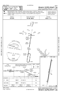
IAC chart of KLXY
 Satellite view of KLXY
Satellite view of KLXY
Sorry, we have no imagery here.
Sorry, we have no imagery here.
Sorry, we have no imagery here.
Sorry, we have no imagery here.
Sorry, we have no imagery here.
Sorry, we have no imagery here.


KLXY - Mexia-Limestone County
Located in Mexia, United States
ICAO - LXY, IATA -
Data provided by AirmateGeneral information
Coordinates: N31°38'28" W96°30'52"
Elevation is 544 feet MSL.
Magnetic variation is 04° East View others Airports in Texas
Operational data
Special qualification required
Current time UTC:
Current local time:
Weather
METAR: KLXY 021215Z AUTO 17014G22KT 5SM HZ OVC022 24/20 A2954 RMK AO2 T02350198 TSNO
Communications frequencies: [VIEW]
Runways:
| RWY identifier | QFU | Length (ft) | Width (ft) | Surface | LDA (ft) |
| 18 | 189° | 5000 | 75 | ASPH | |
| 36 | 9° | 5000 | 75 | ASPH |
Airport contact information
Address: Mexia United States
Satellite view of KLXY
Sorry, we have no imagery here.
Sorry, we have no imagery here.
Sorry, we have no imagery here.
Sorry, we have no imagery here.
Sorry, we have no imagery here.
Sorry, we have no imagery here.