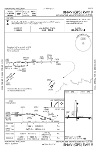
IAC chart of KLUM
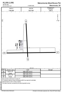
 ADC chart of KLUM
 Satellite view of KLUM
ADC chart of KLUM
Satellite view of KLUM
Sorry, we have no imagery here.
Sorry, we have no imagery here.
Sorry, we have no imagery here.
Sorry, we have no imagery here.
Sorry, we have no imagery here.


KLUM - Menomonie Muni/Score Fld
Located in Menomonie, United States
ICAO - LUM, IATA -
Data provided by AirmateGeneral information
Coordinates: N44°53'32" W91°52'4"
Elevation is 895 feet MSL.
Magnetic variation is 01° East View others Airports in Wisconsin
Operational data
Special qualification required
Current time UTC:
Current local time:
Weather
METAR: KLUM 300615Z AUTO 26004KT 10SM CLR 16/12 A2992 RMK AO2 T01600115 PWINO
Communications frequencies: [VIEW]
Runways:
| RWY identifier | QFU | Length (ft) | Width (ft) | Surface | LDA (ft) |
| 09 | 89° | 5074 | 75 | ASPH | |
| 27 | 269° | 5074 | 75 | ASPH | |
| 18 | 177° | 3470 | 75 | ASPH | |
| 36 | 357° | 3470 | 75 | ASPH |
Airport contact information
Address: Menomonie United States
Other aviation service providers
Flight schools

Satellite view of KLUM
Sorry, we have no imagery here.
Sorry, we have no imagery here.
Sorry, we have no imagery here.
Sorry, we have no imagery here.
Sorry, we have no imagery here.