IAC chart of KLUD
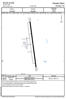
 ADC chart of KLUD
 Satellite view of KLUD
ADC chart of KLUD
Satellite view of KLUD
Sorry, we have no imagery here.
Sorry, we have no imagery here.
Sorry, we have no imagery here.
Sorry, we have no imagery here.
Sorry, we have no imagery here.


KLUD - Decatur Muni
Located in Decatur, United States
ICAO - LUD, IATA -
Data provided by AirmateGeneral information
Coordinates: N33°15'15" W97°34'50"
Elevation is 1046 feet MSL.
Magnetic variation is 09° East View others Airports in Texas
Operational data
Special qualification required
Current time UTC:
Current local time:
Weather
METAR: KLUD 020555Z AUTO 17019G28KT 10SM SCT018 23/19 A2947 RMK AO2 T02290190 10260 20229 402650105
Communications frequencies: [VIEW]
Runways:
| RWY identifier | QFU | Length (ft) | Width (ft) | Surface | LDA (ft) |
| 17 | 172° | 4200 | 60 | ASPH | |
| 35 | 352° | 4200 | 60 | ASPH |
Airport contact information
Address: Decatur United States
Other aviation service providers
Flight schools

Satellite view of KLUD
Sorry, we have no imagery here.
Sorry, we have no imagery here.
Sorry, we have no imagery here.
Sorry, we have no imagery here.
Sorry, we have no imagery here.