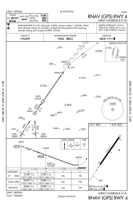
IAC chart of KLUA
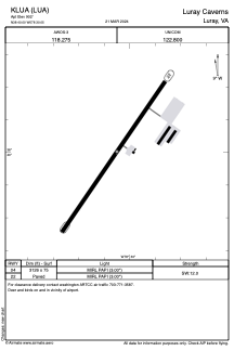
 ADC chart of KLUA
 Satellite view of KLUA
ADC chart of KLUA
Satellite view of KLUA
Sorry, we have no imagery here.
Sorry, we have no imagery here.
Sorry, we have no imagery here.
Sorry, we have no imagery here.
Sorry, we have no imagery here.
Sorry, we have no imagery here.


KLUA - Luray Caverns
Located in Luray, United States
ICAO - LUA, IATA -
Data provided by AirmateGeneral information
Coordinates: N38°40'0" W78°30'3"
Elevation is 902 feet MSL.
Magnetic variation is -09° East View others Airports in Virginia
Operational data
Special qualification required
Current time UTC:
Current local time:
Weather
METAR: KLUA 011535Z AUTO 01005KT 10SM CLR 12/01 A3007 RMK AO2
Communications frequencies: [VIEW]
Runways:
| RWY identifier | QFU | Length (ft) | Width (ft) | Surface | LDA (ft) |
| 04 | 35° | 3126 | 75 | ASPH | |
| 22 | 215° | 3126 | 75 | ASPH |
Airport contact information
Address: Luray United States
Satellite view of KLUA
Sorry, we have no imagery here.
Sorry, we have no imagery here.
Sorry, we have no imagery here.
Sorry, we have no imagery here.
Sorry, we have no imagery here.
Sorry, we have no imagery here.