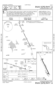
IAC chart of KLSN
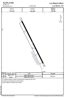
 ADC chart of KLSN
 Satellite view of KLSN
ADC chart of KLSN
Satellite view of KLSN
Sorry, we have no imagery here.
Sorry, we have no imagery here.
Sorry, we have no imagery here.
Sorry, we have no imagery here.
Sorry, we have no imagery here.
Sorry, we have no imagery here.


KLSN - Los Banos Muni
Located in Los Banos, United States
ICAO - LSN, IATA - LSN
Data provided by AirmateGeneral information
Coordinates: N37°3'50" W120°52'11"
Elevation is 121 feet MSL.
Magnetic variation is 16° East View others Airports in California
Operational data
Special qualification required
Current time UTC:
Current local time:
Weather at : KMCE - Merced Yosemite Rgnl ( 40 km )
METAR: KMCE 051053Z AUTO 00000KT 10SM CLR 07/04 A3021 RMK AO2 SLP231 T00670039
TAF: KMCE 050520Z 0506/0606 VRB05KT P6SM SKC FM051200 VRB05KT P6SM SCT250 FM051800 32004KT P6SM SKC FM060000 35005KT P6SM BKN250
Communications frequencies: [VIEW]
Runways:
| RWY identifier | QFU | Length (ft) | Width (ft) | Surface | LDA (ft) |
| 14 | 153° | 3801 | 75 | ASPH | |
| 32 | 333° | 3801 | 75 | ASPH |
Airport contact information
Address: Los Banos United States
Satellite view of KLSN
Sorry, we have no imagery here.
Sorry, we have no imagery here.
Sorry, we have no imagery here.
Sorry, we have no imagery here.
Sorry, we have no imagery here.
Sorry, we have no imagery here.