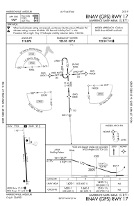
IAC chart of KLRY
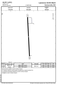
 ADC chart of KLRY
 Satellite view of KLRY
ADC chart of KLRY
Satellite view of KLRY
Sorry, we have no imagery here.
Sorry, we have no imagery here.
Sorry, we have no imagery here.
Sorry, we have no imagery here.
Sorry, we have no imagery here.
Sorry, we have no imagery here.


KLRY - Lawrence Smith Meml
Located in Harrisonville, United States
ICAO - LRY, IATA -
Data provided by AirmateGeneral information
Coordinates: N38°36'37" W94°20'37"
Elevation is 915 feet MSL.
Magnetic variation is 04° East View others Airports in Missouri
Operational data
Special qualification required
Current time UTC:
Current local time:
Weather
METAR: KLRY 050515Z AUTO 02011G17KT 10SM OVC009 08/06 A3014 RMK AO2
Communications frequencies: [VIEW]
Runways:
| RWY identifier | QFU | Length (ft) | Width (ft) | Surface | LDA (ft) |
| 17 | 177° | 4000 | 75 | ASPH | 4000 |
| 35 | 357° | 4000 | 75 | ASPH | 4000 |
Airport contact information
Address: Harrisonville United States
Satellite view of KLRY
Sorry, we have no imagery here.
Sorry, we have no imagery here.
Sorry, we have no imagery here.
Sorry, we have no imagery here.
Sorry, we have no imagery here.
Sorry, we have no imagery here.