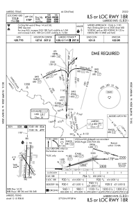
IAC chart of KLRD
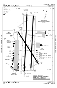
 ADC chart of KLRD
 Satellite view of KLRD
ADC chart of KLRD
Satellite view of KLRD
Sorry, we have no imagery here.
Sorry, we have no imagery here.
Sorry, we have no imagery here.
Sorry, we have no imagery here.
Sorry, we have no imagery here.
Sorry, we have no imagery here.


KLRD - Laredo Intl
Located in Laredo, United States
ICAO - LRD, IATA - LRD
Data provided by AirmateGeneral information
Coordinates: N27°32'39" W99°27'42"
Elevation is 508 feet MSL.
Magnetic variation is 05° East View others Airports in Texas
Operational data
Special qualification required
Current time UTC:
Current local time:
Weather
METAR: KLRD 021256Z 16009KT 6SM BR CLR 23/21 A2949 RMK AO2 SLP984 T02330211
Communications frequencies: [VIEW]
Runways:
| RWY identifier | QFU | Length (ft) | Width (ft) | Surface | LDA (ft) |
| 14 | 147° | 5927 | 150 | CONC | 5927 |
| 32 | 327° | 5927 | 150 | CONC | 5927 |
| 18L | 183° | 8236 | 150 | CONC | 8236 |
| 36R | 3° | 8236 | 150 | CONC | 8236 |
| 18R | 183° | 8743 | 150 | CONC | 8743 |
| 36L | 3° | 8743 | 150 | CONC | 8623 |
Airport contact information
Address: Laredo United States
Satellite view of KLRD
Sorry, we have no imagery here.
Sorry, we have no imagery here.
Sorry, we have no imagery here.
Sorry, we have no imagery here.
Sorry, we have no imagery here.
Sorry, we have no imagery here.