IAC chart of KLOM
 ADC chart of KLOM
 Satellite view of KLOM
ADC chart of KLOM
Satellite view of KLOM
Sorry, we have no imagery here.
Sorry, we have no imagery here.
Sorry, we have no imagery here.
Sorry, we have no imagery here.
Sorry, we have no imagery here.
Sorry, we have no imagery here.


KLOM - Wings Fld
Located in Philadelphia, United States
ICAO - LOM, IATA - BBX
Data provided by AirmateGeneral information
Coordinates: N40°8'15" W75°15'55"
Elevation is 301 feet MSL.
Magnetic variation is -12° East View others Airports in Pennsylvania
Operational data
Special qualification required
Current time UTC:
Current local time:
Weather
METAR: KLOM 081315Z AUTO 29011G21KT 260V320 10SM CLR 02/M08 A2979 RMK AO2 T00191079
Communications frequencies: [VIEW]
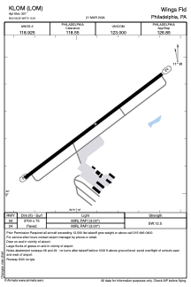
Runways:
| RWY identifier | QFU | Length (ft) | Width (ft) | Surface | LDA (ft) |
| 06 | 53° | 3700 | 75 | ASPH | |
| 24 | 233° | 3700 | 75 | ASPH |
Airport contact information
Address: Philadelphia United States
Other aviation service providers
Flight schools

Satellite view of KLOM
Sorry, we have no imagery here.
Sorry, we have no imagery here.
Sorry, we have no imagery here.
Sorry, we have no imagery here.
Sorry, we have no imagery here.
Sorry, we have no imagery here.