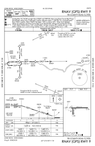
IAC chart of KLNR
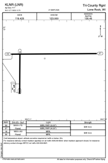
 ADC chart of KLNR
 Satellite view of KLNR
ADC chart of KLNR
Satellite view of KLNR
Sorry, we have no imagery here.
Sorry, we have no imagery here.
Sorry, we have no imagery here.
Sorry, we have no imagery here.
Sorry, we have no imagery here.
Sorry, we have no imagery here.


KLNR - Tri-County Rgnl
Located in Lone Rock, United States
ICAO - LNR, IATA - LNR
Data provided by AirmateGeneral information
Coordinates: N43°12'43" W90°10'47"
Elevation is 717 feet MSL.
Magnetic variation is 00° East View others Airports in Wisconsin
Operational data
Special qualification required
Current time UTC:
Current local time:
Weather
METAR: KLNR 302256Z AUTO 28011KT 10SM CLR 23/09 A2978 RMK AO2 SLP079 T02280094
Communications frequencies: [VIEW]
Runways:
| RWY identifier | QFU | Length (ft) | Width (ft) | Surface | LDA (ft) |
| 09 | 89° | 5000 | 75 | ASPH | |
| 27 | 269° | 5000 | 75 | ASPH | |
| 18 | 180° | 1850 | 60 | ASPH | |
| 36 | 360° | 1850 | 60 | ASPH |
Airport contact information
Address: Lone Rock United States
Satellite view of KLNR
Sorry, we have no imagery here.
Sorry, we have no imagery here.
Sorry, we have no imagery here.
Sorry, we have no imagery here.
Sorry, we have no imagery here.
Sorry, we have no imagery here.