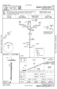
IAC chart of KLLN
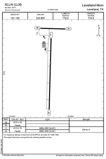
 ADC chart of KLLN
 Satellite view of KLLN
ADC chart of KLLN
Satellite view of KLLN
Sorry, we have no imagery here.
Sorry, we have no imagery here.
Sorry, we have no imagery here.
Sorry, we have no imagery here.
Sorry, we have no imagery here.
Sorry, we have no imagery here.


KLLN - Levelland Muni
Located in Levelland, United States
ICAO - LLN, IATA -
Data provided by AirmateGeneral information
Coordinates: N33°33'9" W102°22'21"
Elevation is 3514 feet MSL.
Magnetic variation is 09° East View others Airports in Texas
Operational data
Special qualification required
Current time UTC:
Current local time:
Weather at : KLBB - Lubbock Preston Smith Intl ( 53 km )
METAR: KLBB 021353Z 29012KT 10SM BKN250 10/M06 A2967 RMK AO2 SLP010 T01001061
TAF: KLBB 021120Z 0212/0312 29011KT P6SM SCT100 FM021600 28015G25KT P6SM FEW100 FM030100 23011KT P6SM OVC070
Communications frequencies: [VIEW]
Runways:
| RWY identifier | QFU | Length (ft) | Width (ft) | Surface | LDA (ft) |
| 08 | 92° | 2072 | 55 | ASPH | |
| 26 | 272° | 2072 | 55 | ASPH | |
| 17 | 182° | 6110 | 75 | ASPH | |
| 35 | 2° | 6110 | 75 | ASPH |
Airport contact information
Address: Levelland United States
Satellite view of KLLN
Sorry, we have no imagery here.
Sorry, we have no imagery here.
Sorry, we have no imagery here.
Sorry, we have no imagery here.
Sorry, we have no imagery here.
Sorry, we have no imagery here.