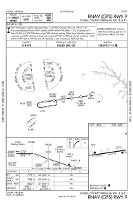
IAC chart of KLKU
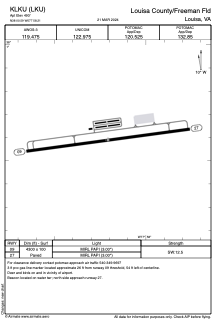
 ADC chart of KLKU
 Satellite view of KLKU
ADC chart of KLKU
Satellite view of KLKU
Sorry, we have no imagery here.
Sorry, we have no imagery here.
Sorry, we have no imagery here.
Sorry, we have no imagery here.
Sorry, we have no imagery here.
Sorry, we have no imagery here.


KLKU - Louisa County/Freeman Fld
Located in Louisa, United States
ICAO - LKU, IATA - LOW
Data provided by AirmateGeneral information
Coordinates: N38°0'35" W77°58'12"
Elevation is 493 feet MSL.
Magnetic variation is -10° East View others Airports in Virginia
Operational data
Special qualification required
Current time UTC:
Current local time:
Weather
METAR: KLKU 010955Z AUTO 33006KT 10SM CLR 09/05 A2989 RMK AO2 T00910049
Communications frequencies: [VIEW]
Runways:
| RWY identifier | QFU | Length (ft) | Width (ft) | Surface | LDA (ft) |
| 09 | 82° | 4300 | 100 | ASPH | |
| 27 | 262° | 4300 | 100 | ASPH |
Airport contact information
Address: Louisa United States
Other aviation service providers
Flight schools

Central Virginia Flight Services
Central Virginia Flight Services
cvflightservices@aol.com+1(540)967-1695
Satellite view of KLKU
Sorry, we have no imagery here.
Sorry, we have no imagery here.
Sorry, we have no imagery here.
Sorry, we have no imagery here.
Sorry, we have no imagery here.
Sorry, we have no imagery here.