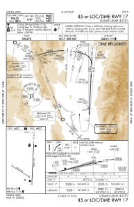
IAC chart of KLGU
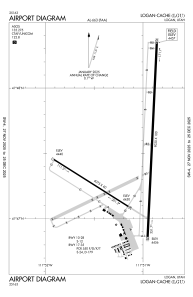
 ADC chart of KLGU
 Satellite view of KLGU

ADC chart of KLGU
Satellite view of KLGU
Sorry, we have no imagery here.
Sorry, we have no imagery here.
Sorry, we have no imagery here.
Sorry, we have no imagery here.
Sorry, we have no imagery here.
Sorry, we have no imagery here.


KLGU - Logan-Cache
Located in Logan, United States
ICAO - LGU, IATA - LGU
Data provided by AirmateGeneral information
Coordinates: N41°47'30" W111°51'6"
Elevation is 4457 feet MSL.
Magnetic variation is 11° East View others Airports in Utah
Operational data
Special qualification required
Current time UTC:
Current local time:
Weather
METAR: KLGU 011451Z AUTO 32005KT 10SM OVC060 01/M01 A2967 RMK AO2 SLP052 60005 T00061011 52012
TAF: KLGU 011304Z 0113/0212 32007KT 4SM -SN BR BKN030 FM011330 VRB06KT P6SM VCSH SCT020 BKN060 FM011700 31010KT P6SM VCSH SCT035 BKN050 FM020000 VRB05KT P6SM BKN050
Communications frequencies: [VIEW]
Runways:
| RWY identifier | QFU | Length (ft) | Width (ft) | Surface | LDA (ft) |
| 10 | 122° | 4075 | 60 | ASPH | |
| 28 | 302° | 4075 | 60 | ASPH | |
| 17 | 183° | 9020 | 100 | ASPH | 9020 |
| 35 | 3° | 9020 | 100 | ASPH | 9020 |
Airport contact information
Address: Logan United States
Other aviation service providers
Flight schools

Mountain Ridge Helicopters, Llc
Mountain Ridge Helicopters, Llc
info@mountainridgeheli.com+1(435)752-3828
Satellite view of KLGU
Sorry, we have no imagery here.
Sorry, we have no imagery here.
Sorry, we have no imagery here.
Sorry, we have no imagery here.
Sorry, we have no imagery here.
Sorry, we have no imagery here.