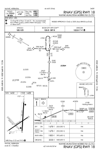
IAC chart of KLCG
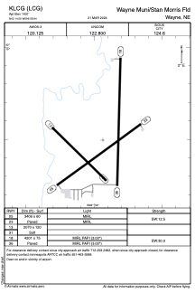
 ADC chart of KLCG
 Satellite view of KLCG
ADC chart of KLCG
Satellite view of KLCG
Sorry, we have no imagery here.
Sorry, we have no imagery here.
Sorry, we have no imagery here.
Sorry, we have no imagery here.
Sorry, we have no imagery here.
Sorry, we have no imagery here.


KLCG - Wayne Muni/Stan Morris Fld
Located in Wayne, United States
ICAO - LCG, IATA -
Data provided by AirmateGeneral information
Coordinates: N42°14'30" W96°58'56"
Elevation is 1431 feet MSL.
Magnetic variation is 06° East View others Airports in Nebraska
Operational data
Special qualification required
Current time UTC:
Current local time:
Weather
METAR: KLCG 050735Z AUTO 35012G17KT 10SM CLR 00/M03 A3038 RMK AO2 T10031026
Communications frequencies: [VIEW]
Runways:
| RWY identifier | QFU | Length (ft) | Width (ft) | Surface | LDA (ft) |
| 05 | 54° | 3406 | 60 | CONC | |
| 23 | 234° | 3406 | 60 | CONC | |
| 13 | 135° | 2070 | 120 | GRASS | |
| 31 | 315° | 2070 | 120 | GRASS | |
| 18 | 181° | 4201 | 75 | CONC | |
| 36 | 1° | 4201 | 75 | CONC |
Airport contact information
Address: Wayne United States
Satellite view of KLCG
Sorry, we have no imagery here.
Sorry, we have no imagery here.
Sorry, we have no imagery here.
Sorry, we have no imagery here.
Sorry, we have no imagery here.
Sorry, we have no imagery here.